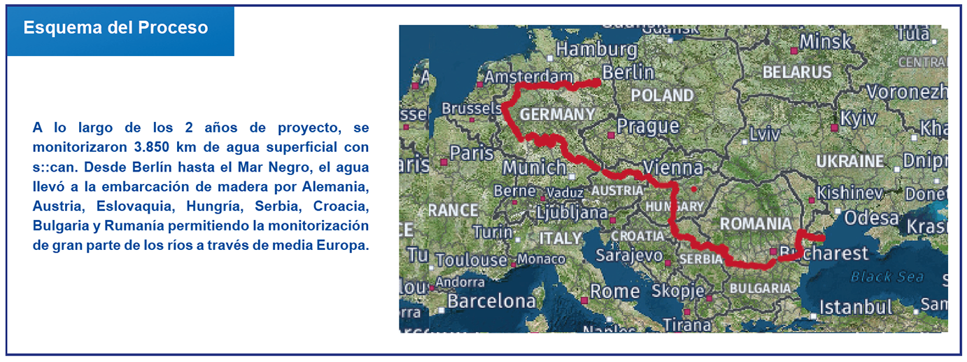
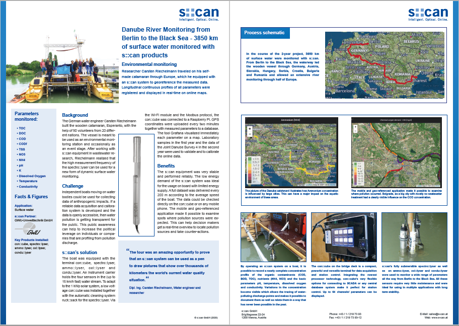
El investigador Carsten Riechelmann viajó en su catamarán, hecho por él mismo, a través de Europa, equipado con un sistema s::can para la georeferenciación de los datos monitorizados. Se registraron perfiles longitudinales continuos de todos los parámetros y se mostraron en mapas online y en tiempo real.
La monitorización del río Danubio desde Berlín hasta el Mar Negro – 3.850 km de agua superfi cial monitorizada con productos s::can

Background
Background
The German water engineer Carsten Riechelmann built the wooden catamaran, Esperanto, with the help of 90 volunteers from 20 different nations. The vessel is meant to be used as an environmental monitoring station and occasionally as an event stage. After working with s::can equipment in waste water research, Riechelmann realized that the high measurement frequency of the spectro::lyser can be used for a new form of dynamic surface water monitoring.
Challenge
Independent boats moving on water bodies could be used for collecting data of anthropogenic impacts. If a reliable data acquisition and calibration system is developed and the data is openly accessible, then water pollution is getting transparent for the public. This public awareness can help to increase the political leverage on individuals or companies that are profiting from pollution discharge.
s::can`s solution
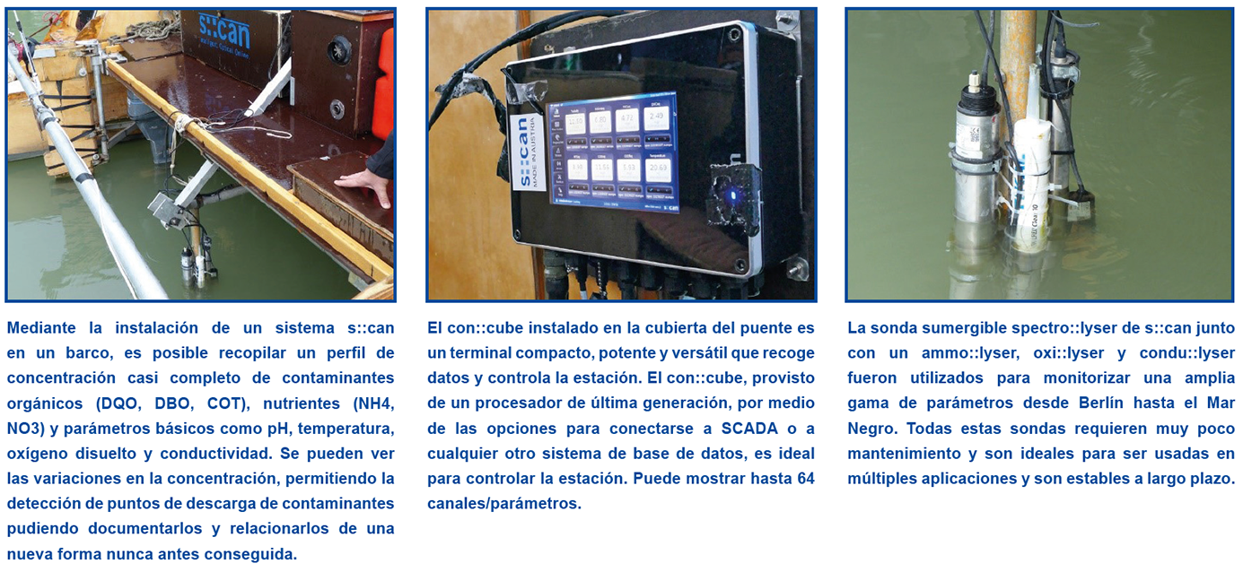
The boat was equipped with the terminal con::cube, spectro::lyser, ammo::lyser, oxi::lyser and condu::lyser. An instrument carrier holds the four sensors in the (up to 15 km/h fast) water stream. To adapt to the 1 kWp solar system, a low voltage con::cube was installed together with the automatic cleaning system ruck::sack for the spectro::lyser. Via the Wi-Fi module and the Modbus protocol, the con::cube was connected to a Raspberry PI. GPS coordinates were uploaded every two minutes together with measured parameters to a database. The tool Grafana visualized immediately each parameter on a map. Laboratory samples in the first year and the data of the Joint Danube Survey 4 in the second year were used to validate and to calibrate the online data.
Beneficios
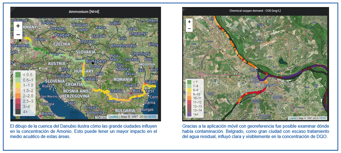
El equipo s::can demostró ser muy estable y fiable. La baja demanda de energía del sistema s::can era ideal para ser usada a bordo donde el suministro de energía es limitado. Un conjunto completo de datos era recopilado cada 200 m, según la velocidad media del barco. Los datos se podían consultar directamente en el terminal con::cube o en cualquier teléfono móvil. La aplicación móvil con georeferencia permitió examinar los puntos donde se esperaban focos de contaminación. Ésto puede ayudar a que los responsables obtengan una visión global en tiempo real para localizar las fuentes de contaminación y poder tomar contramedidas.
Artículos relacionados
-
Control continuo de los vertidos de aguas residuales de la incineradora de Saint Thibault les Vignes
 Monitorización en línea de la calidad de las aguas residuales procedentes de la planta de incineración y tratamiento…
 -
Nueva fecha del seminario web ¡la con::line!
 Abril 2023 I En este seminario web, Roman Morawek y Christoph Wagner presentaran nuestro nuevo terminal de bajo consumo, alimentado…
 -
Control del agua de captación para el bien público
 Mercury, una de las empresas de servicios energéticos de Nueva Zelanda, ha instalado una solución s::can de control del agua…